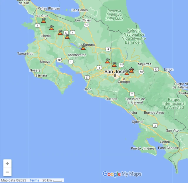
Map of Costa Rica Volcanoes
Costa Rica is situated firmly (ish!) on the Pacific Ring of Fire, an area of the Earth stretching from New Zealand, up through the Pacific Islands, Papua New Guinea, Indonesia, the Philippines, Japan, Eastern Russia and across to Alaska and down the Pacific Coasts of Canada and the US, Mexico and onwards down to Chile. This is an area of earthquakes and volcanoes. About 90% of all earthquakes on earth occur within the Ring of Fire, and it possesses 75% of all volcanoes on the planet. Out of these volcanoes, Costa Rica has 112, of which 60 are considered dormant and 5 are considered active. Here is the map of the most popular volcanoes:
Costa Rica’s rich biodiversity is due greatly to the presence of its volcanoes. As the volcanoes erupt, they deposit minerals into the soil, making the land fertile, and so promoting the growth of the rain forest that used to cover the entire country. Costa Rica’s volcanoes contribute to eco-tourism, with many of them being relatively easy to view/access and learn about.
Costa Rica’s Top Volcanic Attractions
Arenal Volcano
When one imagines a volcano in their mind, they imagine Arenal Volcano. The quintessential “volcano cone shape”, Arenal sits on the Northern Plains of Costa Rica close to the town of La Fortuna. This is the most famous volcano in Costa Rica and was the countries most active one between 1968 and 2010. Since then, things have calmed down, and it is now considered to be “sleeping”. The national park around Arenal provides great hiking, and the natural volcanic hot springs that are produced by the volcano provide soothing relief. This area is considered the “eco-tourism” capital of Costa Rica and offers more to do in terms of hiking, rafting, rappelling etc than anywhere else in the country. Last eruption: 2010
Poas Volcano
The second largest crater of active volcanoes in the world! At just over an hour north of San Jose, Poas offers a great day trip from the capital. Situated in the dense cloud forest, it’s nonetheless easy to reach, and it’s possible to drive almost straight up to the main crater, where you’ll find a surreal views of an acid lake. The second crater is surrounded by cloud forest and contains rain-fed lake. Poas is best seen at dawn as clouds cover the craters very quickly. Last eruption: 2011
Turrialba Volcano
Adjacent to Irazu, Turrialba volcano is nowhere near as easily reached. There is a viewing platform once you make it to the summit, but this volcano is currently in activity since 2010 and hiking is not recommended. Explosions a larger and more frequent since beginning of 2015 with biggest one happening on March 12th, sending an ash cloud over the Central Valley and subsequently closing the biggest airport in the country for a day. This was the biggest eruption in the past 20 years and experts agree that there might be more in the upcoming period.
Irazu Volcano
Most famous for its 1963-1965 eruption which showered San Jose with ash on the day of President John F. Kennedy’s official visit, Irazu is another volcano close to San Jose, east of the capital. At 3,432 meters (11, 260 feet), it’s the highest active volcano in Costa Rica, and is also easily reached as a day trip. Last eruption: 1994
Rincon de la Vieja Volcano
Situated in Guanacaste Province, in the north of Costa Rica, the Rincon de la Vieja rises out of the heat soaked northern flatlands like a mirage. A great day trip from the Guanacaste beach resort areas, Rincon offers great hiking as well as hot springs and vitamin-enriched mud pools to bathe in. Last eruption: 2011